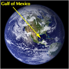
The Gulf of Mexico
Basic Information
[21]
Area: 1,530,387 km2
Coral reefs: 0.6 % of world
Sea mounts: 0.0 % of world
Primary production: 570 mgC·m-2·day-1
Coral reefs: 0.6 % of world
Sea mounts: 0.0 % of world
Primary production: 570 mgC·m-2·day-1
Oceanography

[23]

[24]
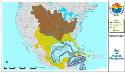
The Gulf of Mexico resembeles a large pit with a broad shallow rim. It is a Mediterranean-type sea and is bordered by the United States to the north (Florida, Alabama, Mississippi, Louisiana, Texas), five Mexican states to the west (Tamaulipas, Veracruz, Tabasco, Campeche, Yucatan), and the island of Cuba to the southeast (1).
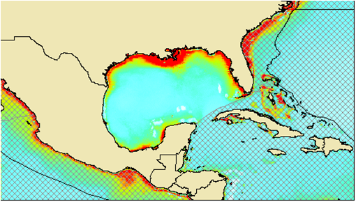
The Gulf of Mexico contains a loop current. The current is fed by the Caribbean current and the Yucatan Current. These currents transport surface waters of tropical origin into the Gulf of Mexico where it then feeds the Florida current and transports heat poleward. Sea suface temperature is related to the loop current. Along the loop current where the white arrows are concentrated is the warmest water, around 80 degrees F.
The Gulf of Mexico contains a loop current. The current is fed by the Caribbean current and the Yucatan Current. These currents transport surface waters of tropical origin into the Gulf of Mexico where it then feeds the Florida current and transports heat poleward. Sea suface temperature is related to the loop current. Along the loop current where the white arrows are concentrated is the warmest water, around 80 degrees F.
[25]
Primary Production
Primary production is measured by milligrams of carbon per meter squared per day. Some months in the year are more prodcutive then others. The figure above shows that the productivity is highest in the months of March and April. This is due to the organisms that produce the carbon. The main producers of carbon in the Gulf of Mexico are many different species of phytoplankton. These organisms have a large population increases during the spring monthes and then their populations crash. Another source of carbon is from photosynthesis by the the brown algae Sargassum that creates large mats along the surface waters.
a

[26]
The light areas along the coast line are phytoplankton blooms when the population is substatinal in size.
a

[27]
Phytoplankton species that produce carbon and increase the primary productivity in the Gulf of Mexico
Biodiversity
Habitats
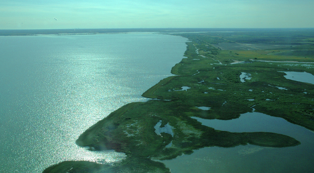
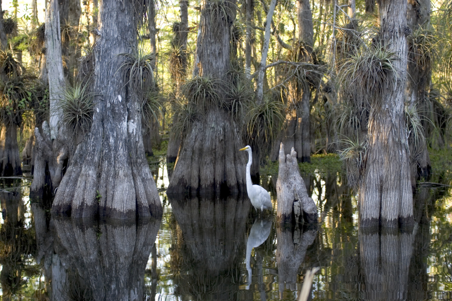
Gulf of Mexico contains a variety of habitats some of the most pronounced of these habitats includes bays, estuaries, coral reefs, islands and banks. Where this fresh water meets the sea and mixes is known as an estuary. Estuaries provide critical feeding, spawning, and nursery habitats for a variety of species(4). Estuaries also support submerged aquatic vegetation communities which stabilize shorelines from erosion, reduce nonpoint source pollution loadings, improve water clarity, and provide habitat(5).
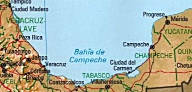
Bays are bodies of water that are partly enclosed by land, which are smaller than gulfs but larger than coves. A large bay in the Gulf is the Bay of Campeche located in Mexico in the Southern Gulf. During the months of June and July this area is considered one of the "hot" breeding spots for Atlantic hurricanes (8). The bay is also considered the eastern border on the main migration routes for birds in the Americas (9).
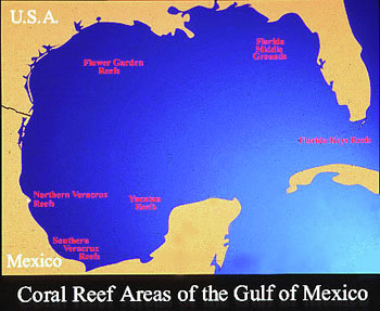
Corals are colonial invertabrates that provide habitats for high number of marine organims. Coral reefs are known as the "rain forest's" of the ocean due to the large biodiveristy that is found on them.
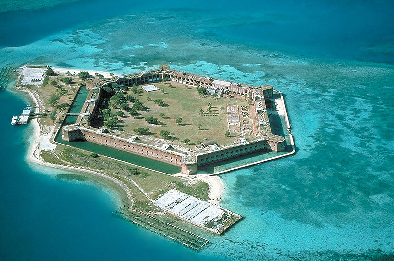
Islands can be formed a few different ways such as through volcanic activity, sediment deposition from coral growth, and techtonic plate movement. Some of the best known islands in the Gulf of Mexico are the Florida Keys are exposed portions of an ancient coral reef (6).
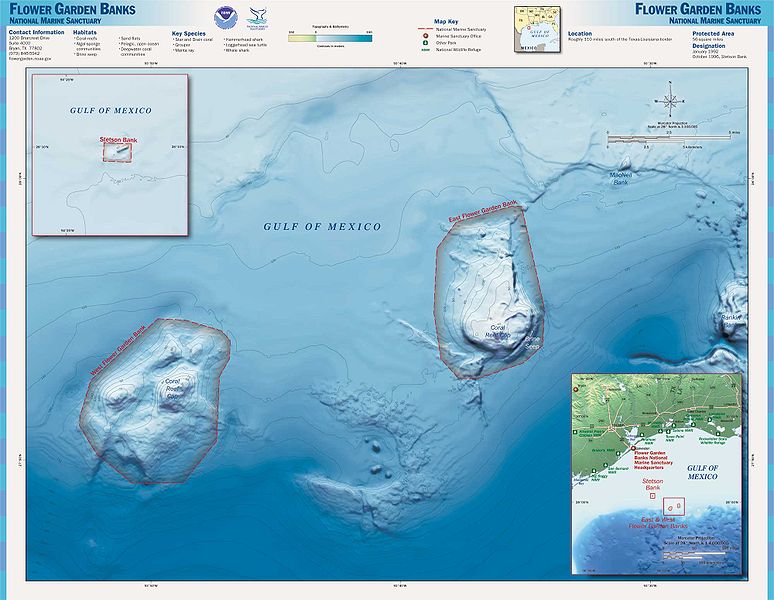
Banks are formations of offshore salt domes and provide a site for colonization of corals. In the Gulf two reefs, the East Flower Garden Bank and the West Flower Garden Bank were formed roughly ten to fifteen thousands years ago. These areas were created into a National Marine Sanctuary in 1992 (1).
Bays are bodies of water that are partly enclosed by land, which are smaller than gulfs but larger than coves. A large bay in the Gulf is the Bay of Campeche located in Mexico in the Southern Gulf. During the months of June and July this area is considered one of the "hot" breeding spots for Atlantic hurricanes (8). The bay is also considered the eastern border on the main migration routes for birds in the Americas (9).
Corals are colonial invertabrates that provide habitats for high number of marine organims. Coral reefs are known as the "rain forest's" of the ocean due to the large biodiveristy that is found on them.
Islands can be formed a few different ways such as through volcanic activity, sediment deposition from coral growth, and techtonic plate movement. Some of the best known islands in the Gulf of Mexico are the Florida Keys are exposed portions of an ancient coral reef (6).
Banks are formations of offshore salt domes and provide a site for colonization of corals. In the Gulf two reefs, the East Flower Garden Bank and the West Flower Garden Bank were formed roughly ten to fifteen thousands years ago. These areas were created into a National Marine Sanctuary in 1992 (1).
Food Web

[33]
Due to the large geographic area of this regoin there are a variety of habitats and ecosystems. Within each of these areas there is a food web that is specific to that area. Above is a simplified version of a food web in the Gulf of Mexico. Other habitats with similar but more intricate systems include coastal ecosystems, off shore ecosystems, the upper photic zone, and deep ocean. For a detailed version of each of these ecosystems visit National Geographics resources for life.
Historical Use of Region
a
[34]
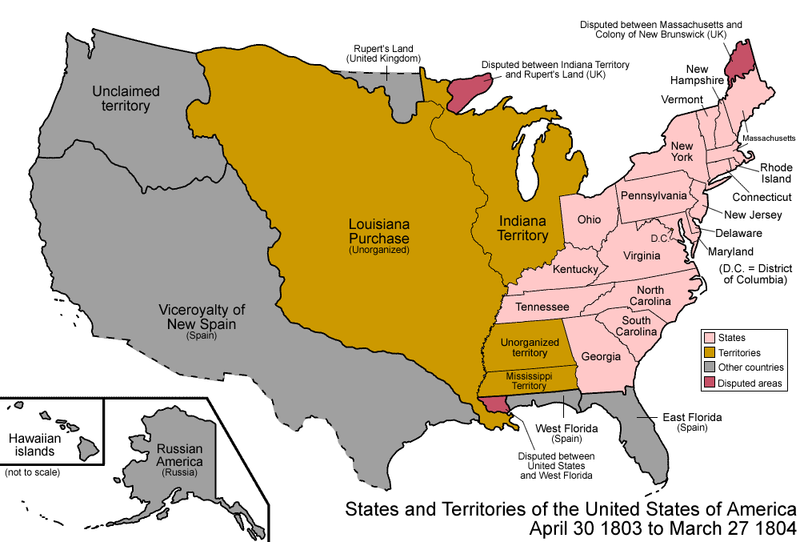
Although Christopher Columbus is often credited with the discovery of the Americas he or his ships never made it to the Gulf of Mexcio. The first documented European exploration of the Gulf of Mexico was by Amerigo Vespucci in 1497. First explored by the Spanish and French the Gulf coast became part of the US in the first half of the 19th century, through the Texas Revolution and the Louisiana Purchase.The South provided access to shipping lanes and was a major source of national and international commerce. The development of sugar and cotton production (enabled by slavery) allowed the South to prosper, however the American Civil War and the Hurricane of Galveston in 1900 severly impacted the economy. In 1901 oil was discoverd in Texas beginning the era of the "Oil Boom" which started a frenzy of exploration and economic development in the US (10). In 2010 the Deepwater Horizon offshore drilling rig exploded off the coast of Lousiana pumping 4.9 million barrels of oil into the Gulf becoming the largest oil spill ever seen in the world.
[35]
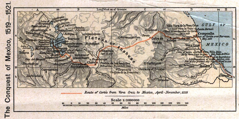
Yucatán, Campeche and Tabasco are all states of Mexico boarding the southern Gulf. This region was home to the Maya people who constructed the only fully developed written language of the pre-Columbian Americas (11). In 1517, Diego Velázquez de Cuéllar, Governor of Cuba, commissioned three ships, under the command of Hernández de Córdoba, to explore the Yucatán peninsula. After Córdoba was mortally wounded Velázquez decided to send another exploration to the coast. This time he sent Hernán Cortés to initiate trade relations with the indigenous coastal peoples. Cortés, recognizing the riches of the unexplored territory convinced Velázquez to allow him to take measures into his own authority if necessary. Fearing that Cortés would try to establish his own colony Velázquez tried to have Cortés removed, but failed and thus began the Spanish conquestion of Mexico (12). In the 19th century Mexico began its war with Spain to gain independance, which was finally granted in 1821. This Gulf region was important for mining, fishing and agriculture as well as freshwater from the Veracruz region (13). Mining and petroleum refinement continue to be major economic secotrs in this region.
Major Fisheries
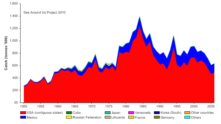
Above are pictures of the major fisheries in the Gulf of Mexico. Species are listed in order of catch per thousand tonnes. This information is summarized in the Seas Around Us Project 2010 graph below.
a

[44]
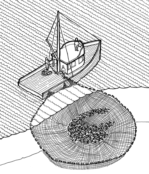
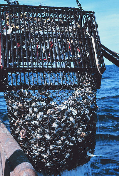
The four major fisheries in the Gulf of Mexico are the Gulf Menhaden, American cupped oyster, Northern brown shrimp and Blue Crab. The majority of these fish are caught by US fishermen and have been for the past 50 years. A comparison in raw numbers shows that in 2006 the US caught 368,743 thousand tonnes of Gulf Menhaden (which is used for fish meal) vs 26,667 in Mexico. The major way these fish are caught are through 4 fishing techniques. Three of the major techniques are listed below in order of usage. The first is the purse seine where a boat encircles a catch and the bottom of the net closes like a purse. The second technique is the bottom trawl which is typically used for catching shrimp. Often times boats will have one of these on each side and drag them together across the bottom. The third pictured technique is the bottom dredge. This is one of the most destructive modes of fishing as everything in its path is swept into the dredge. This produces a lot of bycatch which are non-target species that are often discarded over the side dead. The fourth most common and not pictured means of fishing in the Gulf is through the use of traps. Crab traps for Blue crab are typically used in the US while Mexico uses Octopus traps to catch the common octopus.

[47]
Fisheries Management
US Management
[48]
It is important to keep in mind that the Gulf of Mexico is comprised of both Mexico and United States EEZs (Economic Exclusive Zones). This means that this one body of water is managed by two countries with different interests and affluencys. In the US different branches of government oversee different areas of the ocean. The individual state governments oversee the first three nautical miles from shore. The rest of the 200 mile EEZ is up to the federal government to manage (7). The the Magnuson-Stevens Fishery Conservation and Managment Act of 1976 created eight regional fisheries in the Gulf of Mexico. Federal managment programs include the National Ocean and Atmospheric Administration (NOAA) which manage these areas through balancing social and economic goals, protecting sensitive habitats, setting annual catch limits and establishing limitd access privilage programs (2).
Mexican Management
On the Mexican side of management in the Gulf of Mexico the National Commission of Aquaculture and Fisheries in charge and deals with monitoring and enforcing the Mexican waters. The Mexican Official Standards (NOMs) deal with regulations for fisheries. Their goals are to exploit fisheries resources in a sustainable way, increase economic and social profitability of fisheries and aquaculture, increase legal certainty in fishing and aquaculture activities and promote support programs for fishing and aquaculture activities.
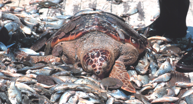
Bycatch is referred to non-target organisms that come up with the catch and are often discarded[49]
Fisheries Problems
Some problems with fisheries in the Gulf of Mexico have arisen. Overfishing continues in seek of greater and greater catch sizes. With the sizeable amount of fishing done every year in this region fish populations can not reproduce fast enough. Bycatch is a main source of overfishing in the Gulf. Bycatch is catching of non-target species that often results in these species death and discardment over the boats edge. Organisms such as turtles, sand dollars and sea horses are caughted by the thousands every year due to bycatch. Managements have tried enforcing regulations, but this is difficult to do in large areas and between two different countries. Corruption is also problem that minimizes the effectiveness of regulations. A lucrative black market also continues for fish species that are highly prized and often rare and overfished. Managements tend to focus on the protection of species that are endangered or threatened without regard of species before they are to this level.
Habitat Changes
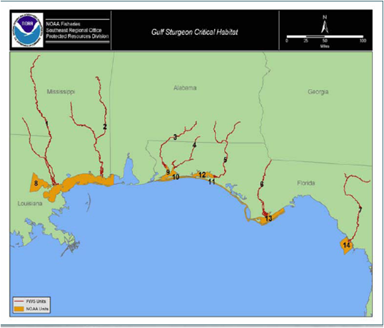
Map of critical sturgeon habitat[50]
Erosion is a chronic problem along the US open-ocean shores. For the Gulf of Mexico region, rates of erosion are generally highest in Louisiana along barrier island and headland shores associated with the Mississippi delta. Erosion also is rapid along some barrier islands and headlands in Texas, whereas barrier islands in Mississippi are migrating laterally. Highest rates of erosion in Florida are generally localized around tidal inlets. The most stable Gulf beaches generally are along the west coast of Florida, where low wave energy and frequent beach nourishment minimize erosion. Some long beach segments in Texas have accreted as a result of net longshore drift convergence and around tidal inlets that have been stabilized by long jetties. Individuals and some communities have attempted to mitigate the effects of erosion by emplacement of coastal structures, but those efforts largely have been abandoned in favor of periodic beach nourishment (14).
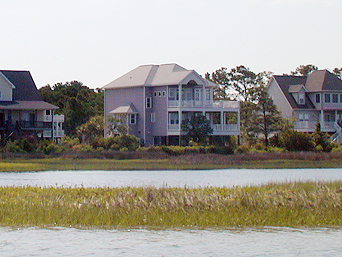
Habitat loss and fragmentation is also a problem in this area. With populations increasing there has been a greater demand for coastal development. Development and around in critical habitats such as estuaries can disrupt ecosystem function and food webs.
Habitat loss and fragmentation is also a problem in this area. With populations increasing there has been a greater demand for coastal development. Development and around in critical habitats such as estuaries can disrupt ecosystem function and food webs.
Introduced species
Invasive or introduced species are organisms that live outside their natural distribution or range due to accidental or purposeful introduction by humans. Some organisms are harmful to native ecosystems out competeing native plants and animals while others are not. Above is a list of major invasive species found in the Gulf of Mexico. For further species refer to http://nas.er.usgs.gov/default.aspx.
Pollution
a
[61]
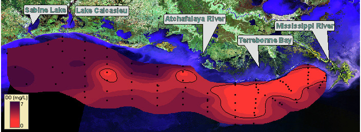
Drainage coming from river inputs causes large amounts of sediments and freshwater to enter the gulf. More than 150 rivers drain into the gulf, 85% of that input is from US rivers and 64% is contributed by the Mississippi alone. Nutrient input (the input of phosperous and nitrogen) in the gulf contributes to a major source of pollution. Additons of nutrients cause large phytoplankton blooms, which eventually die. As they die bacteria feed on the detrital matter and respire the oxygen out of the water. This is what is called a dead zone, an area with insufficant oxygen for most living organims to survive.
[62]
Examples of annual pollutant and nutrient loading in the region are(1):
* over 800,000 tons of nitrogen
* over 200,000 tons of phosphorus
* 100 million tons of dredged sediments
* over 2,000 tons of toxic substances from coastal industrial and municipal sites (four of the top five states in the U.S. in total surface discharge of toxic chemicals are Gulf States - Alabama, Mississippi, Louisiana and Texas)
* approximately 1,000 tons of pesticides from coastal agriculture
* over 6,000 tons of produced waters from near-shore oil and gas platforms
Other forms of pollution include debris from discarded fishing gear and garbage and chemical inputs from tankers. Some ways organims are effected are by physical entanglement, consumption of non-digestible materials, and direct toxicity from chemicals. Direct effects on the biota of the region have lead to a diminuation of variety and abundance of flora and fauna (1). These impacts also have economic effects on health, tourism, recration and the sustaniability of the fishing industry.
Issues Specific to the Region
Deepwater Horizon was an ultra-deepwater, dynamically positioned, semi-submersible offshore oil drilling rig owned by Transocean and built in Korea in 2001. It was leased to BP until 2013. On April 20th, 2010 a surge of oil caused the blowout preventer to fail and an explosion sank the rig, spilling oil into the gulf. 4.9 million barrels of oil spilled into the gulf between April 20th and Septemeber 19th, 2010 when the spill was finally capped. Individiaul organisms, ecosystems, fishermen and tourism were all things that were affected by the spill. There is also not a lot known about what will happen to the organisms and the area as a spill of this magnitude has never been seen before.
Solutions?
The Oil Pollution Act authorizes certain federal agencies, states and Indian tribes, known as the natural resoruce trustees to evaluate the impacts of oil spills, ship grounds, and hazardous substance releases on natural resources. These trustees are responsibe for studying the effects of a spill through a process of Natural Resource Damage Assessment. Some of these agencys include NOAA, US Coast Guard and the EPA. Currently NOAA is conducting the following three steps in a NRDA: Primary assessment, injury assessment/restoration planning, restoration implemenation (2). Though it will take a long time for the area to recover steps like these should speed up the process. Currently some fisheries have re-opened and clean up continues.
References
Text References
1. Gulfbase.org
2. Noaa.gov
3. http://nas.er.usgs.gov/default.aspx
4. U.S. EPA.: 1992, Toxic Substances and Pesticides Action Agenda for the Gulf of Mexico. US Environmental Protection Agency, September 1992.
5. Macauley et al., ESTIMATING THE ECOLOGICAL CONDITION OF THE ESTUARIES OF THE GULF OF MEXICO. Environmental Monitoring and Assessment 57: 59–83, 1999.
6.http://www.nps.gov/nps/
7. www.oregon.gov/LCD/OCMP/docs/Ocean/otsp_1-c.pdf
8.Hauptmann, David. "Where do hurricanes form and where do they strike?"
9. "Routes of Migration". Migration of Birds. Northern Prairie Wildlife Research Center.
http://www.npwrc.usgs.gov/resource/othrdata/migratio/routes.htm
10.Daniel Yergin, The Prize, New York: Simon & Schuster, 1991
11. The Maya (Sixth edition - ed.). New York -: Dante Reed
12.Thomas, Hugh. Conquest: Montezuma, Cortés, and the fall of Old Mexico
13. Schmal, John P. (2004). "The History of Veracruz". Houston Institute for Culture.
14. Mortont, R., Moore, L., Miller, T., Historical Shoreline Changes Along the US Gulf of Mexico:A Summary of Recent Shoreline Comparisons and Analyses Journal of Coastal Research, Vol. 21, No. 4, 2005
Image References
[1]noaa.gov
[2]http://en.wikipedia.org/wiki/File:Octopus_vulgaris2.jpg
[3]http://oceanexplorer.noaa.gov
[4]nmfs.noaa.gov
[5]http://www.boemre.gov
[6]visibleearth.nasa.gov
[7]oceanexplorer.noaa.gov
[8]globalwarming.house.gov
[9]noaa.gov
[10]epa.gov
[11]oceanexplorer.noaa.gov
[12]ars.usda.gov
[13]library.noaa.gov
[14]oceanexplorer.noaa.gov
[15]gomr.boemre.gov
[16]library.noaa.gov
[17]nps.gov
[18]ecy.wa.gov
[19]noaanews.noaa.gov
[20]josephcao.house.gov
[21]nasa.gov
[23]noaa.gov
[24]noaa.gov
[25]seasaroundus.org
[26]nasa.gov
[27]http://en.wikipedia.org/
[28]http://www.tpwd.state.tx.us
[29]http://www.noaa.gov/features/monitoring_0209/estuaries.html
[30]http://en.wikipedia.org/wiki/File:Flower_Gardens_NMS_map.jpg
[31]http://upload.wikimedia.org/wikipedia/commons/6/63/Bay_of_Campeche.jpg
[32]http://en.wikipedia.org/wiki/File:Fort-Jefferson_Dry-Tortugas.jpg
[33]www.epa.gov/
[34]http://en.wikipedia.org/wiki/File:United_States_1803-04-1804-03.png
[35]http://en.wikipedia.org/wiki/File:Conquest_mexico_1519_21.png
[36]article.wn.gov
[37]http://upload.wikimedia.org/wikipedia/commons/6/63/Bay_of_Campeche.jpg
[38]http://en.wikipedia.org/wiki/File:Penaeus_monodon.jpg
[39]http://en.wikipedia.org/wiki/File:Blue_crab_on_market_in_Piraeus_-_Callinectes_sapidus_Rathbun_20020819-317.jpg
[40]maps.thefullwiki.org
[41]http://en.wikipedia.org/wiki/File:Calico_scallop_02.jpg
[42]http://en.wikipedia.org/wiki/File:Mugil_cephalus.jpg
[43]nmfs.noaa.gov
[44]seasaroundus.org
[45]http://en.wikipedia.org/wiki/File:Purse_seine_illustration,_Historic_American_Engineering_Record.png
[46]http://en.wikipedia.org/wiki/File:Old_Trawling_Nets.jpg
[47]seasaroundus.org
[48]noaa.gov
[49]noaa.gov
[50]library.fws.gov
[51]http://coastalscience.noaa.gov
[52]doi.gov/archive/news/archives_may_aug.html
[53]http://coastalscience.noaa.gov
[54]nas.er.usgs.gov/default
[55]nas.er.usgs.gov/default
[56]nas.er.usgs.gov/default
[57]nas.er.usgs.gov/default
[58]nas.er.usgs.gov/default
[59]nas.er.usgs.gov/default
[60]nas.er.usgs.gov/default
[61]noaa.gov
[62]commerce.gov
[63]dec.state.ak.us
[64]Noaa.gov
[65]http://en.wikipedia.org/wiki/File:C-130_support_oil_spill_cleanup.jpg
[66]durbin.senate.gov
[67]http://en.wikipedia.org/wiki/File:Oil_containment_boom.jpg
