The Coral Sea
Introduction
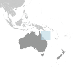
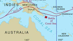
The Coral Sea is located off the Eastern coast of Australia known as Queensland and includes the Great Barrier Reef. It is a marginal sea meaning it is partially closed by land and an arc of Islands. The islands surrounding the sea are, Papua New Guinea, The Solomon Islands, Vanuatu, and New Caledonia. The Coral Sea is one of the regions with the greatest biodiversity in the world. It is currently the largest Unesco World Heritage Site and may soon become the largest Marine Protected Area. The sea is home to sunken battle ships from the Battle of the Coral Sea in May 1942, six of the seven species of sea turtles, and a substantial tuna fishery. The Coral Sea is a popular tourist destination and one of the best managed regions in the world.
Coral Sea Map [1]Max Depth: 9,140m
Surface Area: 4,791,000km2
Water Volume: 11,470,000km3
Bordering Countries:
•Australia
•New Caledonia
•Papua New Guinea
•Solomon Islands
•Vanuatu
Table of Contents:
1. Basic Information
i. Hydrology
ii. Primary Productivity
2. Historical Uses
3. Biodiversity
i. Habitats
ii. Common Species
4. Food Web
5. Major Fisheries
6. Fisheries Management
7. Habitat Change
8. Introduced Species
9. Marine Protected Areas
10. References
1. Basic Information
i. Hydrology
ii. Primary Productivity
2. Historical Uses
3. Biodiversity
i. Habitats
ii. Common Species
4. Food Web
5. Major Fisheries
6. Fisheries Management
7. Habitat Change
8. Introduced Species
9. Marine Protected Areas
10. References
Basic Information
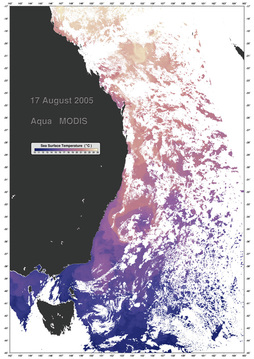
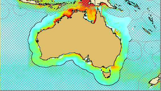
Hydrology: The East Australian Current is the strongest in Australian waters and pulls warm nutrient poor water from the Coral Sea along the coast of Australia until it meets with the cooler waters of the Tasman Sea. In the North the Coral Sea is relatively warm with sea surface temperatures ranging from 27-28°C but much cooler in the south with temperatures from 19-24°C. The water is very clear and visibility in most areas is 30m. The picture to left represents sea surface temperatures off the eastern coast of Australia.
[Image 2]
[Image 2]
Primary Productivity [3]
The primary productivity in the Coral Sea is relatively low at 516 mgC·m-2·day-1. In order for coral to obtain sunlight the water must be clear, this leads to a lower abundance of phytoplankton. Nutrient levels are low in the Coral Sea due to high concentrations of light, this means that most of the primary production is due to pico phytoplankton which thrive in low nutrient conditions. Primary productivity is highest off the Australian coast during November and remains high throughout April until a crash in May when temperatures decrease.
Historical Use of the Region
Top Image [12] Bottom Image [13]
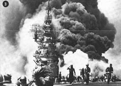
Battle of the Coral Sea
The Battle of the Coral Sea occurred in May 1942, and was a pivotal turning point in World War II. It was the first battle fought strictly between planes aircraft carriers, a battle in which enemy ships never saw each other. The Imperial Japanese were attempting to gain territory in the Southern Pacific and destroy Australia’s forces. After several days of battle both sides suffered innumerable losses. Although it was a tactical win for the win for the Japanese, ultimately it proved to be a positive outcome for the Allies as it was the first time Japanese forces were stopped.
Ecosystems & Biodiversity
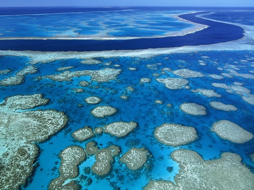
Great Barrier Reef [11]
Habitats
Coral Reefs:
Coral reefs are the most prominent habitat in the Coral Sea. There are over four hundred species of corals found in this region. Coral reefs contain photosynthetic algae called zooxanthellae living in their tissues. The reef and algae have a mutualistic relationship, meaning the relationship is beneficial to both parties. The zooxanthellae receive a protected environment as well as compounds necessary for photosynthesis. In return the algae produce oxygen necessary for the corals and aid in removal of wastes. Most importantly, the zooxanthellae provide corals with the waste products of photosynthesis; glucose, glycerol, and amino acids. The coral takes these waste products and uses them to make fats, proteins, and carbohydrates, as well as to produce calcium carbonate which provides them structure. Because reef building corals contain algae they behave like plants and require clear water to receive sunlight. This is why reefs are found in shallow waters, typically with visibility of thirty meters. [15]
Seagrass beds:
Within sea grass beds there are a number of organisms such as sea stars, sea cucumbers, conch, snapper, parrotfish, rays, and sharks. Hundreds of sea birds populate this region as well, such as the Corroboree Sea Eagle. Sea grass beds provide nursing grounds for young fish as well as juvenile crabs. They also supply dugongs and sea turtles with food. [Image 16]

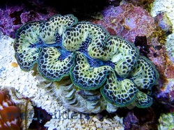
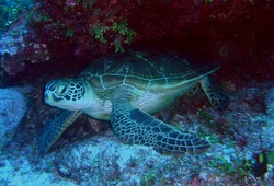
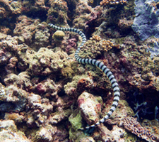
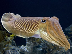
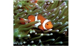
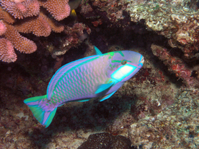
Common Coral Sea Species:
From left to right: Giant Clam [5] , Cuttle Fish [6], Green Sea Turtle [7], Clown Fish [8], Sea Snake [9], and Parrot Fish [10]. See food web below for further explanation of interactions amongst the organisms of the Coral Sea.
From left to right: Giant Clam [5] , Cuttle Fish [6], Green Sea Turtle [7], Clown Fish [8], Sea Snake [9], and Parrot Fish [10]. See food web below for further explanation of interactions amongst the organisms of the Coral Sea.
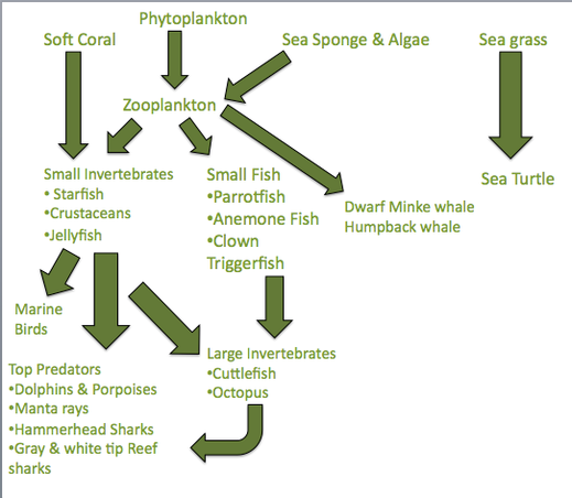
Marine Food Web
The food web of the Coral Sea is quite complex. At the bottom of the food chain are phytoplankton specifically diatoms and dinoflagellates. Next, sea sponges, algae, soft corals, and zooplankton. Then, small invertebrates like the hermit crab, crown of thorns starfish, giant clam, and jellyfish which consumer phytoplankton and zooplankton. Moving on up the web you find over 1200 species of fish, three of which include anemone fish also known as clown fish, clown triggerfish, and the yellowfin tuna which is in incredibly high demand by fisheries. There are also large invertebrates such as the octopus, and cuttlefish. Large predators include white & grey tip reef sharks as well as dolphins, porpoise, and whales.
Major Fisheries
Large Marine Ecosystem: Northeast Australian Shelf Fisheries [11]
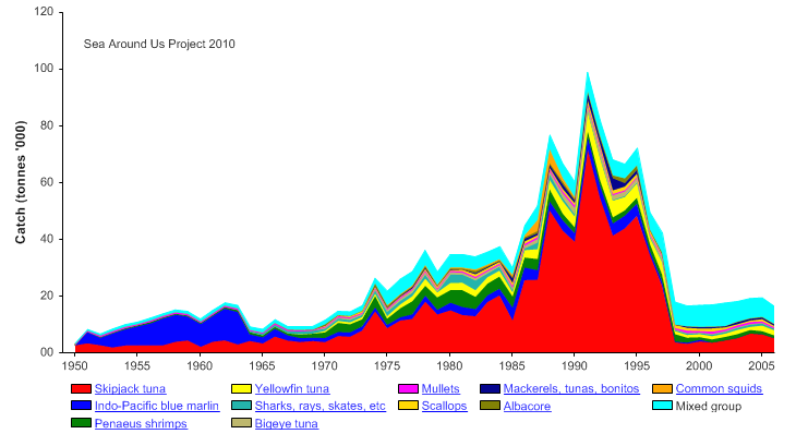
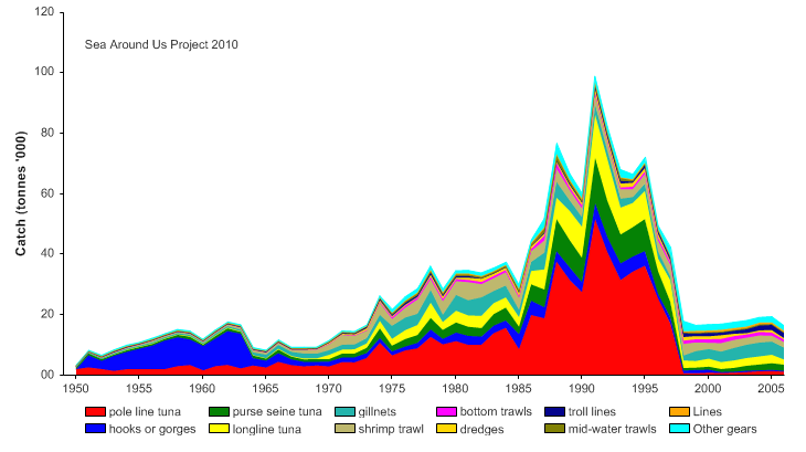
The greatest abundance of fish harvested in the Coral Sea are taken from the Northeast Australian Shelf. The two most commercially fished species are the Skipjack Tuna and Yellowfin Tuna. Due to the increasing popularity of sushi, tuna is in high demand globally, and up until the creation of a multi-governmental fisheries management program Japan was the dominating fishing power in the Coral Sea. Pole line, longline, and purse seine nets are the most common methods of harvesting the fish. Since the main harvested species is a migratory fish it cannot be exploited year round. This results in relatively low annual catch numbers. The largest annual catch for the region is roughly 100,000 tonnes, which is far lower than most of the other seas described on this site. Below are graphs representing the catch by species [14] and gear used [15] over the past fifty-five years. The most predominately fished species in the Solomon Islands, Vanuatu, New Caledonia, and Papua New Guinea are also the yellowfin tuna and skipjack tuna.
Fisheries Management
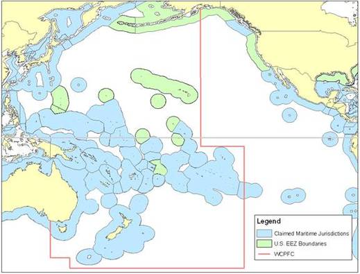
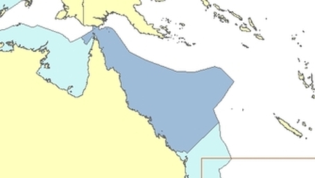
The Western and Central Pacific Fisheries Commission (WCPFC) manage highly migratory tuna in the Pacific Ocean. Tuna in the Coral Sea cannot only be managed by one country, since they are migratory fish they must be managed year round by all of the countries with waters they may inhabit. The WCPFC was established in June 2004, prominent members of the commission are west of the red line in the image [17] above. All five countries bordering the Coral Sea are a part of the WCPFC and the new management has provided the rights for smaller countries like the Solomon Islands, Vanuatu, and New Caledonia to have access to their valuable fish stocks.
Habitat Changes
Climate change is bound to have a profound impact on the Coral Sea. Carbon dioxide emissions from land result in dissolved carbon dioxide in the oceans. Dissolved carbon dioxide decreases ocean pH thus making the oceans more acidic. Corals cannot tolerate acidic waters, and as oceans continue to become more acidic from human activities there is potential for coral reefs to suffer significant irreversible damage. Corals are currently considered to be in 'crisis' due to warming temperatures and rising ocean acidification. The Great Barrier Reef has yet to suffer from extensive bleaching, but several reefs throughout the world in places like the Maldives, Seychelles and Palau have already shown devastating evidence of coral bleaching. The potential effects of Climate change on marine ecosystems is not currently fully understood but scientists in the region are doing everything they can to understand the changes in order to protect the Coral Sea. (Click the habitat changes title to view the current status of climate change in the Great Barrier Reef)
Introduced Species
The Management of Introduced species in the Coral Sea is of high concern. Due to the relatively isolated location of The Coral Sea, the Queensland government has created very strict restrictions about what is and is not allowed into the country and it's waters. The potential for invasion by boat hulls and ballast water is always present. However in the Great Barrier Reef Marine Park Authority there has not been a detection of any introduced marine species outside of ports. There are several terrestrial species such as rats, cats, and goats inhabiting islands of the Great Barrier Reef but they have not shown any potentially harmful effects on the reef.
Marine Protected Areas
A marine protected area, commonly known as an MPA is defined as a region of ocean regulated by law to protect the living and non-living of the region as well as historical and cultural resources. More information can be found here, NOAA MPA's. The Great Barrier Reef is the second largest marine protected area on earth. It is regulated by the Great Barrier Reef Marine Park Authority, and is currently considered to be the gold standard of ecosystem based MPA management. Ecosystem based management (EBM) is currently perceived to be one of the best strategies for managing marine ecosystems. It has been demonstrated that analyzing single threats to environments does not work, thus an approach accounting for all aspects of ecosystem interactions like EBM is now being put into place.
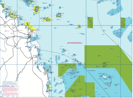
The Great Barrier Reef Marine Park Authority (GBRMPA) was established in 1975, initially to protect the region from exposure to oil drilling. The GBRMPA has become one of the most intricate and well managed regions thanks to their intensive zoning practices, emphasis on marine reserves, linking governments, and community education and involvement. In 2004 rezoning increased marine reserve areas from 4.4% to 33.3%, below is an example of a zoning region (Green = Marine National Park, no take zone Dark Blue = Trawling Prohibited Yellow = Conservation park with limited fishing Light Blue = general use). [18]
The Great Barrier Reef Marine Park Authority (GBRMPA) was established in 1975, initially to protect the region from exposure to oil drilling. The GBRMPA has become one of the most intricate and well managed regions thanks to their intensive zoning practices, emphasis on marine reserves, linking governments, and community education and involvement. In 2004 rezoning increased marine reserve areas from 4.4% to 33.3%, below is an example of a zoning region (Green = Marine National Park, no take zone Dark Blue = Trawling Prohibited Yellow = Conservation park with limited fishing Light Blue = general use). [18]
The Great Barrier Reef Marine Park Authority recently reviewed the status of the park and outlined three objectives for 2010-2014. Below is a list of the objectives with specific goals for the park over the next four years.
Objective 1:Address major risks
- Ecosystem resilience
- Water quality
- Fisheries management
- Climate change
- Bordering ecosystems
Objective 2: Establish sustainable use through management
- Legislation
- Permits
- Protect Cultural Traditions
- Partnerships
Objective 3: Maintain a High performing ecosystem
- Adhere to requirements
- Provide timely & effective advice to government
- Inform management (Large marine advisory committees)
- Ensure GBRMPA remains a leader in MPA management
Much of the success of the GBRMPA stems from its community involvement programs. Specifically through large marie advisory committees. There are eleven committees corresponding to each zoning region of the GBRMPA. Their job is to monitor and report changes in the environment to government as well as involve the community in the preservation of the reef system.
The Coral Sea is one of the regions with the highest biodiversity in the world. It is home to elaborate ecosystems bursting with life and is a popular destination for tourists every year. The Great Barrier Reef Marine Park Authority is currently considering expanding its boundaries to the exclusive economic zone of Australian waters. If approved the new marine park would be the largest in the world covering over 972,000 square kilometers. For more information on the expansion project and the importance of preserving this area visit the website for The Protect Our Coral Sea Campaign.
Image References:
[1] https://www.cia.gov/library/publications/the-world-factbook/maps/cr_largelocator_template.html
[2]http://visibleearth.nasa.gov/view_rec.php?id=20183
[3] Sea around us
[4] http://www.oceanleadership.org/2009/outlook-poor-for-great-barrier-reef/
[5] http://www.reefbuilders.com/wp-content/gallery/clam/maximabrid-1.jpg
[6] http://www.tnaqua.org/Newsroom/HighRes/ComCuttlefish9.jpg
[7] http://www.photolib.noaa.gov/htmls/reef1480.htm
[8]http://www.mcguinnessonline.com/australia/photos/aus2003/mooloolaba/index.41.jpg
[9] http://coris.noaa.gov/about/eco_essays/palau/terrestrial_eco.html
[10]http://www.photolib.noaa.gov/htmls/reef4416.htm
[11] http://www.seaaroundus.org/lme/40.aspx
[12] http://www.history.army.mil/brochures/72-8/map1.JPG
[13]http://www.nps.gov/archive/wapa/indepth/extContent/wapa/brochure/brochure2c.jpg
[14]http://www.seaaroundus.org/lme/40/1.aspx
[15]http://www.seaaroundus.org/lme/40/5.aspx
[16]http://www.helcom.fi
[17]http://www.fpir.noaa.gov
[18]http://www.gbrmpa.gov.au/corp_site/management/zoning
Other Sources
Introduction:
http://en.wikipedia.org/wiki/Coral_Sea
Basic Information:
http://en.wikipedia.org/wiki/Coral_Sea
Historical Use of the Region:
http://www.history.navy.mil/photos/events/wwii-pac/coralsea/coralsea.htm
Biodiversity & Habitats:
http://oceanservice.noaa.gov/education/kits/corals/coral02_zooxanthellae.html
Marine Food Web:
http://en.wikipedia.org/wiki/Coral_Sea
Introduced Species:
http://www.gbrmpa.gov.au/corp_site/info_services/science_management/table_4_pages/template_page81
Major Fisheries:
http://www.seaaroundus.org
Fisheries Management:
http://www.seaaroundus.org
http://www.wcpfc.int/
Habitat Change:
http://www.gbrmpa.gov.au/corp_site/key_issues/climate_change/climate_change_and_the_great_barrier_reef
Marine Protected Areas:
http://www.gbrmpa.gov.au/
http://www.protectourcoralsea.org.au/help-protect-australia-s-coral-sea
Ruckels Haus, Mary. Klinger, Terrie. Knowlton, Nancy. DeMaster, Douglas P. "Marine Ecosystem-based Management in Practice: Scientific and Governance Challenges." Bioscience 58.1 (2008): 55-66. Print.
http://en.wikipedia.org/wiki/Coral_Sea
Basic Information:
http://en.wikipedia.org/wiki/Coral_Sea
Historical Use of the Region:
http://www.history.navy.mil/photos/events/wwii-pac/coralsea/coralsea.htm
Biodiversity & Habitats:
http://oceanservice.noaa.gov/education/kits/corals/coral02_zooxanthellae.html
Marine Food Web:
http://en.wikipedia.org/wiki/Coral_Sea
Introduced Species:
http://www.gbrmpa.gov.au/corp_site/info_services/science_management/table_4_pages/template_page81
Major Fisheries:
http://www.seaaroundus.org
Fisheries Management:
http://www.seaaroundus.org
http://www.wcpfc.int/
Habitat Change:
http://www.gbrmpa.gov.au/corp_site/key_issues/climate_change/climate_change_and_the_great_barrier_reef
Marine Protected Areas:
http://www.gbrmpa.gov.au/
http://www.protectourcoralsea.org.au/help-protect-australia-s-coral-sea
Ruckels Haus, Mary. Klinger, Terrie. Knowlton, Nancy. DeMaster, Douglas P. "Marine Ecosystem-based Management in Practice: Scientific and Governance Challenges." Bioscience 58.1 (2008): 55-66. Print.
