The Chukchi Sea
Map 1
Table of Contents
Introduction
Currents
Biodiversity and Food Webs
Fisheries
Historical Use
Habitat Change
Invasive Species
A Final Note
Contact Me
Sources
Introduction
Currents
Biodiversity and Food Webs
Fisheries
Historical Use
Habitat Change
Invasive Species
A Final Note
Contact Me
Sources
Introduction
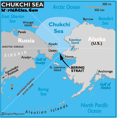
This sea is located between Alaska and Russia and just above the Bering Strait. The sea is approximately 595,000 Km which makes it a little larger than Madagascar and a little smaller than Ukraine. It is a fairly shallow sea, the average depth is only 50 meters. The Chukchi Sea is only navigable four months out of the year, the rest of the time it is covered in ice. The major environmental issue in this region is the melting of this sea ice. This is fundamentally changing the ecosystem.
There is no commercial fishing allowed in the EEZ of the Chukchi Sea until scientists can determine whether this area can handle that kind of stress. There is a small near shore commercial fishery in Kotzebue Sound and a substantial subsistence fishery. There is estimated to be about 30 billion barrels of oil on the Chukchi Shelf, but development is on hold for the moment. However, Alaska is under a lot of pressure to open the sea to drilling, so that could change any moment.
There is no commercial fishing allowed in the EEZ of the Chukchi Sea until scientists can determine whether this area can handle that kind of stress. There is a small near shore commercial fishery in Kotzebue Sound and a substantial subsistence fishery. There is estimated to be about 30 billion barrels of oil on the Chukchi Shelf, but development is on hold for the moment. However, Alaska is under a lot of pressure to open the sea to drilling, so that could change any moment.
Currents
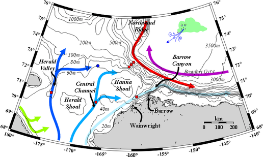
Diagram 1: This is a diagram of the currents going through the north Chukchi Sea and the Beaufort Sea. In the Chukchi Sea darker blue represents more nutrient rich waters and light blue represents nutrient poor waters. Green represents the Siberian Coastal Current which is present in the summer and fall, but is absent or weak in the winter and spring. The red represents the the Atlantic Waters and purple represents the anticyclonic circulation of the Beaufort Gyre. For more about circulation and water properties, please visit http://www.ims.uaf.edu/chukchi/.
Biodiversity and Food Web
Primary Productivity: There are three main types of primary producers in the Chukchi. Ice algae, benthic microalgae, and phytoplankton. Ice algae is the most common around the ice flows while phytoplankton is most common nearer to shore.
There are three groups of mammals that inhabit the top of the food chain: Odontocetes,
Mysticetes, and Carnivora. Birds also make up important parts of the food chain whether they precivores near the top or herbivores near the bottom.
There are three groups of mammals that inhabit the top of the food chain: Odontocetes,
Mysticetes, and Carnivora. Birds also make up important parts of the food chain whether they precivores near the top or herbivores near the bottom.
Odontocetes
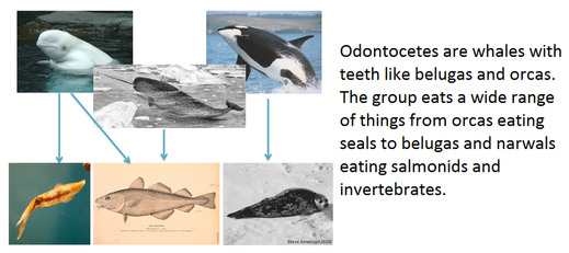
Image 1:This is a simple food web showing Orcas, Belugas, and Narwales at the top of the food chain. Killer whales eat many pinipeds such as the ringed seal, pictured above. Belugas eat salmonids and invertibrates such as pacific cod and squid.
Mysticetes
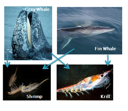
Figure 2
Mysticetes are baleen whales like humpback and bowhead whales. They eat krill and shrimp.
Carnivora
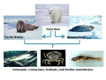
Figure 3
The Carnivora group includes polar bears and pinipeds like walrus and seals. Polar bears eat pinipeds, especially ringed seals. Pinnipeds eat fish, crustaceans, mollusks, and benthic invertebrates like squid.
Birds
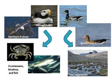
Figure 4
The Chukchi sea hosts hundreds of thousands of birds as they migrate through every year. There are two types of birds: the ones that stay near shore and eat tidal vegetation and the ones that fly out to sea in order to eat fish and crustaceans.
Fisheries
To understand fisheries, we need to know who regulates fishing in the Chukchi Sea. On the United States side, the federal government and the State of Alaska government divide and sometimes share the responsibility. The Federal government regulates all ground fish in the EEZ. The primary governmental body that does this is the National Marine Fisheries Service which is part of NOAA. The state of Alaska operates through the Alaska Department of Fish and Game and regulates all salmon, herring, and shellfish in the waters around Alaska, including those within the EEZ. The Russian Federation regulates fisheries through the Federal Fisheries Committee that is centered in Moscow. This is the counter part to the U.S. National Marine Fisheries Service.
Figure 5
Management areas
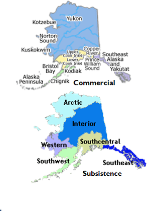
Figure 6
Depending on what type of fishery is being managed, the state of Alaska is split into different areas. For commercial fisheries, the state is split into several southern areas and one northern area. This is because of the relitivley few commercial fisheries in the northern part of the state. For subsistence fisheries, the state is split along native tribes' boundary lines. Each other of these sections is the territory of different major tribes.
Species
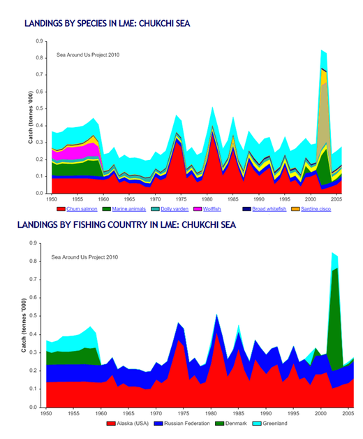
Figure 7
The top image is a graph from the Seas Around Us Project, which shows a relatively low amount of yearly catch; between 200 and 900 metric tonnes. In fact, if you take out the anomaly in 2003, the totals ready get about 500 tones. This spike in 2003 correlates to an increase in fishing by Denmark and Greenland. As you can see in the next image, Denmark fishes almost twice as much as Russia and the U.S. combined those years. there is no literature on why this might be. Also in the bottom image, Denmark and Greenland were major fishers in the Chukchi prior to 1959. This is when Alaska became a state and began managing its own fisheries.
Commercial Fisheries
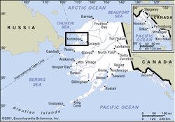
Figure 8
This is the Kotzebue Sound. This is where most fisheries in the Chukchi Sea are. Because of the weather conditions, major fisheries have not developed off shore. There are no major fisheries in the EEZ of the Chukchi Sea according to the North Pacific Management Council. in 2005, it became apparent that the ice was melting significantly enough to allow fisheries to open up. Additionally, pink salmon and walleye have migrated to the Chukchi where they had never been seen before, offering a potential fishery to open. the ntional Marine Fisheries Service started teh Artic Fisheries Managment Plan where they decided not to open any new fisheries until they have enough scientific information to creat a stable pisheries plan. This was passed in 2008.
The rest of the fishereies are commercial fisherieen in the state's 3 mile zone and subsistance fisheries.
The rest of the fishereies are commercial fisherieen in the state's 3 mile zone and subsistance fisheries.
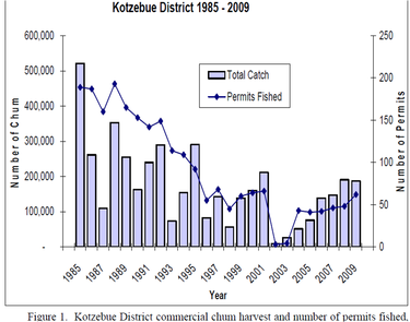
Diagram 2
The biggest fishery is chum salmon in Kotzebue sound. The chum season is from early July till the end of August, just shy of two months. Fisherman can fish from 6am to 2 pm and only on Monday through Saturday. These hours are important for the sustainability because salmon have a tendency to rest during the day and run at night, especially early in the season. in 2009, 187,562 chum were caught for a total of one and a half million pounds. Above is a graph of the catch for the last few years. It is important to remember that while this graph makes it look like total catch is declining each year, this is because the number of permits being given is decreasing. The catch per fisherman is actually increasing.
Subsistence Fisheries
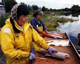
Figure 9
The most complicated fisheries is subsistence. For fishing, residents of Kotzebue area can fish as many fish as they want, whenever they want, for subsistence purposes. The definition of subsistence is as follows:
In the hunter or their family eats all the edible parts and uses the rest for clothing, shelter, or handicrafts. these are restricted to noncommercial, customary, and traditional uses., They can sell their handicrafts for profit, but the rest they have to use for themselves.
In the more northern Chukchi they can fish as much as they like, but only during certain parts of the year depending on where exactly the fishing is taking place. Native Alaskans depend on fishing and hunting in order to survive. They cannot simply go to the grocery store and buy their food. Jobs are limited in these remote areas and groceries must be flown in which drives the cost up considerably. For example, in Kotzebue, a fairly large and connected village, gas is around $7/gallon. Milk is around $9/gallon and ground beef is almost $4/lb. With limited income, you can see why fishing is so important. The native Alaskans have been fishing sustainably for hundreds of years and will continue to do so.
Historical Use
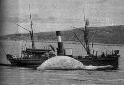
Figure 10
1778- James Cook sailed into the Chukchi sea
1884- Captain Thomas Roys' made a successful exploratory hunt in the Bering sea, which was followed by six decades of whaling.
1892- 32 New Bedford whaling ships were trapped by ice when the wind turned unexpectedly. All crew was saved, but all ships were lost. The company received insurance money, but they reinvested in other things, such as cotton. This was the beginning of the end for the whaling industry. It never fully recovered from this event.
1959- Alaska became a state and took over its own fisheries management
2008- the Arctic Fisheries Managment Plan was established by the North Pacific Managment Council.
Habitat Change
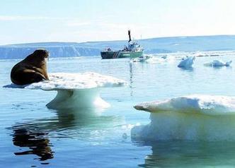
Figure 11
As far as habitat change goes, its not as much what has happened as what is happening and what is about to happen. All the top predators in the Chukchi sea and most of the primary producers rely on the ice flows to survive. Large areas of open ocean become habitat when they are covered in ice. Seals, walrus,and polar bears all rely on ice for hunting, breeding, and denning. Without ice, the animals become stranded on land, overpopulated and unable to hunt as they normally would. The melting sea ice is not just habitat change, but compete and utter habitat destruction.
It is the same with primary production. Ice algea is the biggest primary producer off shore and it lives in and under the ice. Once the ice melts, the primary production will plummet and the area may not be able to support a fraction of what it is able to now.
It is the same with primary production. Ice algea is the biggest primary producer off shore and it lives in and under the ice. Once the ice melts, the primary production will plummet and the area may not be able to support a fraction of what it is able to now.
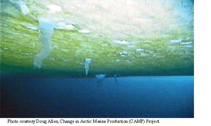
Figure 12. Photo courtesy of Doug Allen
Ice algea- Ice algae is the major source of primary production in the Chukchi sea. It only grows in and around ice sheets. If all the ice melts, ice algae will not be able to grow.
Invasive Species
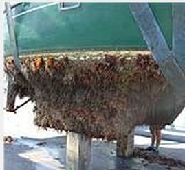
Figure 13
As with habitat change, invasive species isn't as important of a problem at the moment as it is about to become a big issue in the very near future. because of its position and environment, the Chukchi has never had much of a problem with invasive species. theres relitively low shipping traffic to bring foling speces and ballast water and the conditions here are fiarly harsh so it is hard to get established. But global climate change is effecting the Chukchi sea drastically and presenting a lot of new wasy to introduce exotic species. When talking about invasive species, this website will talk a lot about the Arctic Ocean because there is also a lot going on there and everything that is happening to the Arctic Ocean directly effects the Chukchi.
The warming water temperatures and melting ice is directly related to the potential increase in invasive species. Currently, the biggest problem with new speices is the northern movement of speices that are trying to escape warmer waters to the south. As Chukchi waters warm, more species are able to live in the environment, so species are extending their range northward. Pink salmon and walleye polluck who have moved into the Chukchi sea. Bering Flounder and Pacific Cod are moving into the Arctic Ocean. This area is and will continue to experience range shifts of many species. Animals that are already as north as they can go will start to suffer from the heat and their populations may start to decline.
The warming water temperatures and melting ice is directly related to the potential increase in invasive species. Currently, the biggest problem with new speices is the northern movement of speices that are trying to escape warmer waters to the south. As Chukchi waters warm, more species are able to live in the environment, so species are extending their range northward. Pink salmon and walleye polluck who have moved into the Chukchi sea. Bering Flounder and Pacific Cod are moving into the Arctic Ocean. This area is and will continue to experience range shifts of many species. Animals that are already as north as they can go will start to suffer from the heat and their populations may start to decline.
Oil and Gas Resourses
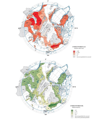
Figure 14
But current species migration pales in comparison to the species the Chukchi may be exposed to in the very near future. The Arctic Ocean is literally standing on the precipice for major changes that could cause massive introduction of new species into an increasingly sensitive ecosystem. As global climate change continues to melt the ice caps, money makers all over the world are turning their eyes north.
Currently, there is no oil and gas drilling in the Chukchi Sea and obviously, theres none in the Northern Arctic Ocean because its covered with ice year round. but according to USGS about a quarter of the world's undiscovered oil and gas resources are in the Arctic ocean. As the ice continues to melt, companies are getting ready to make their move. At present, Alaska is barely holding off Shell from drilling on the Chukchi self. If companies start drilling, the sea will be exposed to a huge increase in shipping traffic with oil barges and transport ships bringing fowling species on their hulls and dumping their ballast waters. The inevitable oil spills and continued increase in water temperature would leave the Chukchi and Arctic vulnerable to a wide range of invasive species.
Currently, there is no oil and gas drilling in the Chukchi Sea and obviously, theres none in the Northern Arctic Ocean because its covered with ice year round. but according to USGS about a quarter of the world's undiscovered oil and gas resources are in the Arctic ocean. As the ice continues to melt, companies are getting ready to make their move. At present, Alaska is barely holding off Shell from drilling on the Chukchi self. If companies start drilling, the sea will be exposed to a huge increase in shipping traffic with oil barges and transport ships bringing fowling species on their hulls and dumping their ballast waters. The inevitable oil spills and continued increase in water temperature would leave the Chukchi and Arctic vulnerable to a wide range of invasive species.
Melting Arctic Ocean
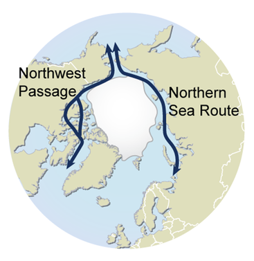
Figure 15. Courtasy of the UNEP: http://maps.grida.no/go/graphic/arctic-sea-routes-northern-sea-route-and-northwest-passage
But that's not all. Currently, there are two trade routes connecting the Atlantic ocean to the Pacific through the Arctic Ocean. The Northern Sea Route along the coast of Russia and the Northwest passage through Canada's Queen Elizabeth Islands. The Northern Sea Route is only navigable for two months out of the year and even then, you can't get a ship through unless you are escorted by a Russian Ice breaker ship. This make this rote very expensive. however, in 2005 the route was opened and a satalite showed that the last ice blockage had melted. but it was closed again in 2007. Again in 2008 it was reported that the ice blockage had melted. Russia has recently had to start allowing ships with reinforced hulls to pass without Russian escort. the Bremen based Beluga Group in 2009 claimed to be the first western company to attempt the Northern Sea Route without the assistance of ice breakers. they are planning for six vessels to make Arctic deliveries this year (2010).
The other passage is the Northwest passage through Canada. in 2007 satalites showed the passage was open, but scientists debate that the images were read wrong and there was still enough ice to prevent large ships from passing through safely. in 2008 it was confirmed that the first commercial ship sailed through the Northwest passage. Passage is currently limited right now because Canada insists that the route goes through Canadian waters, but the U.S. and much of Europe are trying to convince them that the route is an international straight. Hold your ground Canada!
but the point of all this is that major shipping routes are about to open up year round through the Arctic Ocean and all the ships will be funneled through the Chukchi Sea. just as with oil transport ships, this will open up the Chukchi to the risk of invasive species from all over the world, but will provide a much shorter route for species from the Atlantic to the Pacific. Species will be able to cross from Europe to the U.S. with unprecedented ease.
A Final Note
Though the Chukchi Sea seems like a barren iceland, it is full of life. It has so far managed to remain one of the precious few ecosystems in the world that has not been damaged beyond recognition and repair. But as time marches on and the ice continues to melt, the Chukchi will be facing major turning points. The managers of this sea have the opportunity to save or destroy the environment. I know that I personally will be waiting with baited breath to see how the United States and Russia respond to the situation. Please come back to this website to see these major events unfolding. If you have any questions, comments, or news articles, please feel free to contact me using the form below. This page was last edited Dec 7, 2010
Image 1: http://www.solarnavigator.net/animal_
kingdom/cetaceans/fin_whale.htm
http://www.smh.com.au/articles/2007/
11/04/1194117879703.html
Figure 2: http://wildwhales.org/?page_id
=41
http://www.gator-woman.com/finwhale.html
Figure 3:http://en.wikipedia.org/wiki/Bearded_Seal
http://en.wikipedia.org/wiki/Polar_bear
http://en.wikipedia.org/wiki/Walrus?oldid=0
http://commons.wikimedia.org/wiki/
Figure 4: http://en.wikipedia.org/wiki/Northern_Fulmar
http://commons.wikimedia.org/wiki/Main_Page
http://commons.wikimedia.org/wiki/File:Fratercula_corniculataUSFWSSL0002774.jpg
Figure 5:http://www.adfg.state.ak.us/
http://www.noaa.gov/
http://www.alaskafisheries.noaa.gov/regs/summary.htm
Figure 6:http://www.cf.adfg.state.ak.us/
http://www.subsistence.adfg.state.ak.us/
Figure 7: http://www.seaaroundus.org/
Figure 8: http://www.trytobreak.com/martin/alaska.html
Figure 9: http://www.fish4thefuture.com/subsistence.htm
Figure 10: http://commons.wikimedia.org/wiki/File:Chassebaleine.jpg
Figure 11: http://www.smh.com.au/news/environment/arctic-melting-greenhouse-effect-blamed/2005/09/29/1127804597665.html
Figure 12: http://research.iarc.uaf.edu/amg/icephecom.html
Figure 13: http://www.coastalwiki.org/coastalwiki/TBT_and_Imposex
Figure 14: http://maps.grida.no/go/graphic/arctic-sea-routes-northern-sea-route-and-northwest-passage
Others
Map 1: Modified from http://www.worldatlas.com/aatlas/infopage/chukchisea.htm
Diagram 1: http://www.ims.uaf.edu/chukchi/
Diagram 2: http://www.cf.adfg.state.ak.us/region3/yukhome.php
Other Sources
—http://alaska.fws.gov/fisheries/endangered/pdf/consultation_guide/4_Species_List.pdf
http://pubs.aina.ucalgary.ca/arctic/Arctic35-4-485.pdf
http://ak.audubon.org/issues-action/chukchi-sea
http://alaska.boemre.gov/ref/EIS%20EA/Statoil_FEIS/Final%20EA%20Statoill%202010_072210.pdf
http://en.wikipedia.org/wiki/Chukchi_Sea
Gautier et al, 2009. Assessment of Undiscovered Oil and Gas in the Arctic, Science: , Vol. 324 no. 5931 pp. 1175-1179 , DOI: 10.1126/science.1169467
http://www.benfirthstudio.com/jrduckstamp.html
http://animals.howstuffworks.com/mammals/walrus.htm/printable
http://www.mun.ca/biology/scarr/Pusa.htm
http://www.cws-scf.ec.gc.ca/nwrc-cnrf/default.asp?lang=En&n=215B1698-1
http://www.commondreams.org/headline/2009/12/07-13
http://www.worldatlas.com/aatlas/infopage/chukchisea.htm
http://royaldutchshellplc.com/2008/02/04/the-wall-street-journal-alaska-drilling-plans-draw-opposition/
http://www.appinsys.com/GlobalWarming/RS_ArcticIce_2007.htm
Lloyd and Hilsinger, 2009, Alaska Department of Fish and game Division of Commercial
Fisheries News Release. Alaska Department of Fish and Game.
http://www.cf.adfg.state.ak.us/region3/finfish/salmon/catchval/09ktzsalsum.pdf
