THE BAY OF BENGAL
Introduction
This project looks at many different seas around the world. It shows just how diverse this world is but yet still shows how all things are connected to one another. The Bay of Bengal is just one of many interesting parts of this world's oceans. Through the Large Marine Ecosystem project, brought to light by NOAA, this bay is now observed, analyzed, and managed more often than it has been in order to keep the area healthy and productive.
Table of Contents
1. Basic Information
2. Biodiversity
- Primary Productivity
- Invertebrates
- Reptiles
- Mammals
3. Fish and Fisheries
- Fisheries Management
4. Habitats
- Estuaries
- The Sandarban Mangroves
5. Historical Use of the Region
6. Pollution
-Population Statistics
-Study One
-Study Two
7. References
2. Biodiversity
- Primary Productivity
- Invertebrates
- Reptiles
- Mammals
3. Fish and Fisheries
- Fisheries Management
4. Habitats
- Estuaries
- The Sandarban Mangroves
5. Historical Use of the Region
6. Pollution
-Population Statistics
-Study One
-Study Two
7. References
BASIC INFORMATION
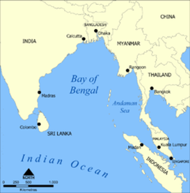
Map of the Bay of Bengal [1]
Location: Northern Indian Ocean.
It is encompassed by the nations of: India, Bangladesh, Myanmar, Indonesia, and Sri Lanka.
Length: 2,090 km
Width: 1,610 km
Surface Area: 3,660,130 km sq.
Average Depth: 2,600 meters
Max Depth: 4,694 meters
It is encompassed by the nations of: India, Bangladesh, Myanmar, Indonesia, and Sri Lanka.
Length: 2,090 km
Width: 1,610 km
Surface Area: 3,660,130 km sq.
Average Depth: 2,600 meters
Max Depth: 4,694 meters
BIODIVERSITY
(1) Primary Productivity
Primary productivity is the basis for measuring how much carbon is within a system. This is the basic building block for an organisms survival. In the first picture of the slide show, this shows an arial view of the bay of bengal and how much average primary productivity there is throughout the year. The calculated amount is approximately 729 milligrams of Carbon per meters squared per day.
(2) and (3) Invertebrates
There are many invertebrates to inhabit the area. As the slide show shows, sea cucmbers are one of the many different echinoderms that exist around this area. While they are nice to look at, on occassion, the local people will take to fishing and consuming them as a source of food. Also, many different types of crustaceans are seen throughout this area. They also are a source of food
(8) and (9) Reptiles
Crocodiles make their way to these parts, not only to use the saltwater as a migratory passage way but also to use the estuaries and wetlands as nesting and breeding grounds. The same goes for the turtles. Their nesting and breeding grounds are within some of the bay's many estuaries and has helped keep this Large Marine Ecosystem more protected.
(10) and (11) Mammals
A quick overview of an extremely rare and unknown species it the Irrawaddy Dolphin. They are very much under-studied and not much is known about them. This picture was a very lucky shot as it is said they do not come out of the water that often. They tend to stay underwater more often than not. They are thought to feed on the smaller fish and rarely do they encounter any real predator of their own.
Most would not think of the Bengal Tiger when thinking about a bay. But as you will see further down the line, there are many mangroves and solid grounds that help protect and secure the Bengal Tiger. They will sometimes feed on fish and sea birds that live within the mangroves as long as they move quick enough to catch them.
Most would not think of the Bengal Tiger when thinking about a bay. But as you will see further down the line, there are many mangroves and solid grounds that help protect and secure the Bengal Tiger. They will sometimes feed on fish and sea birds that live within the mangroves as long as they move quick enough to catch them.
(4)-(7) Fish and Fisheries
There are many different types of fish that thrive in the open ocean. Within the Bay of Bengal, there are now more smaller bait fish that end up being lower on the trophic level that end up fished. The slide show presents different types of mullet and also trumpeter fish that live within this region. Also, there are many game fish, like marlin that inhabit these waters and have been classically overfished not just within these waters but elsewhere around the world as well. Sharks also stalk these territories, mostly staying within the open ocean or in and around the smaller reef areas near Thailand and surrounding islands.
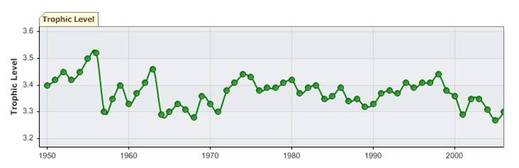
Trophic Level being fished [2]*
This figure above is showing the historical trophic line of what is being caught out of the bay of bengal. As it shown, over the past 60 years, the average trophic level has steadly been going down. This means that more and more fish in the lower trophic levels are being caught and brought back to show. Within the bay, however, management is slightly less than satisfactory, meaning that there is some room for human error.
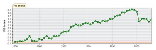
Fish in Balance Index [2]*
The Fish in Balance index is a way of showing a supposed baseline. Strictly speaking this is showing how different in balance or out of balance fish populations are within the Bay of Bengal for the past 60 years. It would seem that the fish have slightly gone away from the 1950s norm.
Fisheries Management
While some of this area is very well researched, it is not completely policed or maintained to the extent it sometimes should be. There are many artisenal fisheries in these parts. For instance only 5% of Bangladesh is said to have commerical fishing; the rest is all local fishing. In the second graph of the slide show, it is shown what types of fish are caught within the bay; as seen, it is said to be a mixed group where not much of it has been separated into their own categories. The catch count graph (#3), is also fairly vague in what is specifically caught; here it just says "fish and inverts" are part of the the big catch, as well as perch-like fish.
There is an organization within the United Nations; the Regional Fishery Bodies out of the Fisheries and Aquaculture Department. The Bay of Bengal has its own regional establishment with only Bangladesh, India, Sri Lanka, and the Maldives taking part in discussions. It is suppose to enhance intergovernmental discussion about the communial bay they all share. There is a governing council that overlooks the different services, which inlcude but are not limited to, management and support, information and communication, and policy and program development services [6].
There is an organization within the United Nations; the Regional Fishery Bodies out of the Fisheries and Aquaculture Department. The Bay of Bengal has its own regional establishment with only Bangladesh, India, Sri Lanka, and the Maldives taking part in discussions. It is suppose to enhance intergovernmental discussion about the communial bay they all share. There is a governing council that overlooks the different services, which inlcude but are not limited to, management and support, information and communication, and policy and program development services [6].
HABITATS
Estuaries and Mangroves
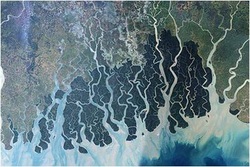
Estuary [14]
The three longest rivers along this sea includes the Ganges, Brahmaputra, and the Irrawaddy. In total there are 39 estuaries that flow into the Bay of Bengal. Estuaries are an incredible and important part of the Bay's ecosystem. The rivers help with depositing nutrients. During the upwelling season, the circulation is continuous allowing for the salt and freshwater to mix and provide an acceptable environment during the early spring and late fall phytoplankton blooms. This is of course when this area is not completely engrossed in a monsoon. This area has variable blooms because of these storms but they can bring a very nice, warm environment with high nutrient and oxygen levels and low salinity [1].
The Sundarban Mangroves, or translated Beautiful Forest, are a very large ecosystem that extends approximately 10,000km sq. where 6,000 of that is in Bangladesh and the other part in northern India. It lies in the vast delta of the Ganges, Brahmaputra and Meghna rivers. It has been originally estimated to be 16,700km sq. in area, but over time, the mangroves and the inhabitants were used for wood, food, and medicinal purposes. It is now more protected due to the fact that it helps house the endangered Bengal Tiger.
Early History Trade Routes within the Bay of Bengal
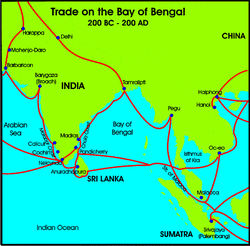
Historical Trade Routes[2]
In ancient times, there was already an established trade route. There seemed to be a great demand for the southeast spices. This was sadi to be a ruthless sea bearing area not only due to rough seas but to the supposed pirates who would lurk and wait for an easy ship to take. As passage started to become consistent, there were many different taxes and laws enforced within this area. It started to become a very lucrative business for its time [3]*.
For a long time in the later 1600s until now, there are certain areas that were colonized by "westerners." The East India Trading company is one of those business that became very lucrative to not only the United Kingdom, but when the French and Dutch governments had their hold on it as well at one time, all countries did fincially pretty well. There were trade routes, taxes, ownerships, and wealth to be had in these Asian countries. The spices and silks were sought after due to their exotic origin. As with all business, there will always be draw backs. Sometimes it became overwhelming to completely control these areas, like in 1770 when a famine ended up wiping out one third of the local population [9]. This area has a varied history, and as history continues to be made, the world wonders if this area will be able to sustain a breathable breath due to a large population and rampant waste associated with it.
For a long time in the later 1600s until now, there are certain areas that were colonized by "westerners." The East India Trading company is one of those business that became very lucrative to not only the United Kingdom, but when the French and Dutch governments had their hold on it as well at one time, all countries did fincially pretty well. There were trade routes, taxes, ownerships, and wealth to be had in these Asian countries. The spices and silks were sought after due to their exotic origin. As with all business, there will always be draw backs. Sometimes it became overwhelming to completely control these areas, like in 1770 when a famine ended up wiping out one third of the local population [9]. This area has a varied history, and as history continues to be made, the world wonders if this area will be able to sustain a breathable breath due to a large population and rampant waste associated with it.
Studies of Pollution in the Area
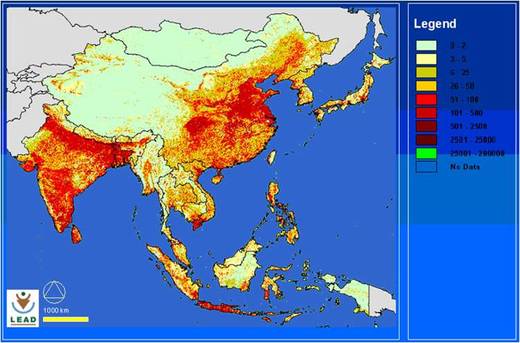
In focusing on pollution in this area, first look at the population density. The more red there is, the higher the density in population (the legen is difficult to read). India, Bangladesh, and Indonesia are in the world's top ten most populous places where around 400 million people live in this large marine ecosystem "catchment" [1]. That is a lot of sewage, runoff, and distrubance to any coastal environment.
[15]
"Level of Heavy Metals in Some Edible Marine Fishes of Mangrove Dominated Tropical Estuarine Areas of Hooghly River, North East Coast of Bay of Bengal, India"
Paper by: T.K. De, M. De, S. Das, R. Ray, P.B. Ghosh
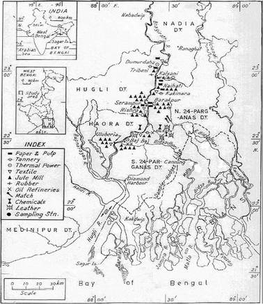
Industry in Bangladesh [7]*
This figure shows the many different industries that run along this river system, which eventually leaks out into the bay. It is believed that these contribute to the heavy metals that occur in some of the fish species that runs along the coastline of this river. There are currently oil refineries, textile, rubber, and paper mills that have gone up in this area.
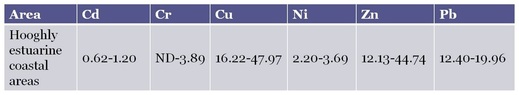
values in mg per kg; and given by [7]*
Having Cadmium, Chromium, Lead showing up in amounts higher than recommended, it can be speculated that more people in these areas could start experiencing lead poisoning, cancerous illnesses, and just over all poorer health. Copper, Nickel, and Zinc are essential nutrients and considering they are naturally in other organisms, like fish it would only deem appropriate to find them within the different kinds of fish studied [7]*.
"Petroleum Hydrocarbon Concentrations in Marine Sediments Along Chennai Coast, Bay of Bengal, India"
by R. Venkatachalapathy, S. Veerasingam, T. Ramkumar
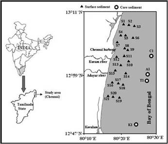
Study sites [8]*
Taking many different core samples along the eastern coastline of India, the scientists were looking at how much petroleum gets into marine sediments and then determine what the consequences of the results might mean for the environment.
The Results showed that there is a larger amount of petroleum in these waters due to the shipping industry, the sewage that gets carried into the sea from inland, and also that because with so many estuaries within this bay, the mud carries the same waste products and soaks up even more petroleum products. The overall consequences of these results are not completely understood, but it can be assumed that nutrients are being lost. It is suggested that this stands to reason that more measures should be put into place to lessen the amounts of waste being put into the ocean. While this is helpful, there really is no actual plan as of right now that will be carried out.
The Results showed that there is a larger amount of petroleum in these waters due to the shipping industry, the sewage that gets carried into the sea from inland, and also that because with so many estuaries within this bay, the mud carries the same waste products and soaks up even more petroleum products. The overall consequences of these results are not completely understood, but it can be assumed that nutrients are being lost. It is suggested that this stands to reason that more measures should be put into place to lessen the amounts of waste being put into the ocean. While this is helpful, there really is no actual plan as of right now that will be carried out.
References
Text and Figure References
[1]* http://www.lme.noaa.gov (search Bay of Bengal)
[2]* http://www.seasaroundus.org (c/o http://www.seaaroundus.org/lme/34.aspx)
[3]* http://nabataea.net/bengal.html (as well as pictures)
[4]* http://www.boblme.org/
[5]* http://www.boblme.org/uploads/BOBLME%20Communications%20Strategy.pdf
[6]* http://www.fao.org/fishery/rfb/bobp_igo/en
[7]* http://www.springerlink.com/content/j12884064xh67296/fulltext.pdf
[8]* http://www.springerlink.com/content/t32015164q436048/fulltext.pdf
[9]* http://en.wikipedia.org/wiki/East_India_Company
Picture References
[1] http://commons.wikimedia.org/wiki/File:Bay_of_Bengal_map.png
[2] http://nabataea.net/bengal.html
[3] http://www.seaaroundus.org/primaryproduction/LMEpp_monthlyimages.htm?CountryID=34&FAO=0&CountryName=Bay of Bengal#
[4] http://www.seashepherd.org/news-and-media/news-070702-1.html
[5] http://www.chartingnature.com/poster.cfm/sustainable-shellfish/116
[6] http://acfishing.com
[7] http://australianmuseum.net.au/image/School-of-Bastard-Trumpeters-at-Shark-Point
[8] http://animaldiversity.ummz.umich.edu/site/accounts/pictures/Makaira_nigricans.html
[9] http://inthu.co.uk/tag/sharks/
[10] http://savethereptiles.wordpress.com/2010/05/06/india-new-jersey-woman-killed-by-crocodile/
[11] http://www.chinadaily.com.cn/life/2009-01/08/content_7378844.htm
[12] http://www.brilliantstudent.in/blog/?m=20090402
[13] http://news.bbc.co.uk/cbbcnews/hi/newsid_7250000
[14] http://tmp.kiwix.org
[15] http://www.google.com/imgresimgurl
[16] http://www.kaladanpress.org/v3/index.php
option=com_content&view=article&id=2080:rohingya-found-dead-in-bay-of-bengal-shore&catid=105:july-2009&Itemid=2
